
AIOLOS PROJECT
period covered: 1/1/2010 - 31/12/2012
host-institution: Cyprus University of Technology (CUT)
scientific coordinator: Dr. Evangelos Akylas
investigators: Dr. Elias Gravanis, Ioannis Kastanas (MSc), Andreas Georgiou (MSc), Panagiotis Zavros (MSc)
budget: 90000 euros (internal funding)
period covered: 1/1/2010 - 31/12/2012
host-institution: Cyprus University of Technology (CUT)
scientific coordinator: Dr. Evangelos Akylas
investigators: Dr. Elias Gravanis, Ioannis Kastanas (MSc), Andreas Georgiou (MSc), Panagiotis Zavros (MSc)
budget: 90000 euros (internal funding)
summary
The last 5 years considerable effort has been done on encouraging investment on wind energy plans in Cyprus. Two wind farms work already on an operational basis and thoughts for further intrusion of the wind energy in the electric power production of the island exist. Energy availability and security of supply are of the most important factors for the economic and social development of the country. Wind power is a form of renewable energy that exhibits increasing commercial success worldwide. According to experts’ predictions, wind power could capture more than 10% of the world energy market by the year 2020, if there are governmental economic incentives and improved technologies (Lee et al., 2009). On the other hand, wind power has some disadvantages as it is considered an intermittent power supply and the superior wind sites are usually located in remote areas (Chompoo-inwai et al., 2008). It is, therefore, imperative in order to provide a reliable and integrated wind resource assessment, that the wind characteristics must be studied in detail at each site separately (Gungor and Eskin, 2008). Cyprus is in its early stages of wind resource developing. The two newly installed wind farms which are fully operational contribute partially to the electric power production of the island. However, there is still considerable lack of scientific works related with the distribution and detailed estimation of the wind potential of Cyprus. Pashardes and Christofides (1995) were the first to try providing a general wind map of Cyprus. Jacovides (2001), examined wind statistics over 5 specific coastal stations and only lately Georgiou et al. (2012) studied in detail a part of Larnaca district. In this project, a first step towards an integrated method for the estimation and analysis of potential wind energy resources in Cyprus is presented and applied at six selected sites at the western part of the island. Statistical analysis of wind speed and direction data shows strong influence of sea-breeze which is very intense, especially in the southern coast. In the case of the northern coast (Polis station), the wind speed remains relatively high also during the night, exhibiting much lower daily variation, although still changing its direction. The wind statistics obtained serve as the basis in order to estimate corrected statistical distributions over the extended areas of application through Wind Atlas Analysis and Application Program (WAsP) which modifies the wind flow due to local topographic effects. Aggregation of the data with statistical weighting methods, allows the extrapolation of the results and the visualization over the western part of the island. The application indicates that interesting points with higher wind energy potential, suitable for wind resource exploitation exist. Further application and inclusion of all the data available from nearby stations is needed in order to improve the accuracy and complete the coverage. The particular methodological framework applied and the results obtained can be utilized by potential investors and wind energy developers.
Methodology
The overall methodology aims to the production of a complete wind power map of Cyprus on a monthly and bi-daily (day–night) basis. Wind measurements were analyzed in order to produce statistics in the form of the Weibull distribution (Seguro and Lambert, 2000). It has to be noted that the power density method for the estimation of the Weibull parameters was chosen (Akdag and Dinler, 2009), since it is more suitable for wind power statistics as it is also discussed by Akylas et al. (2010). The WAsP program was then used in order to produce the corrected wind speed and power statistics over the extended area around each station and the resulting data are aggregated and visualized through ArcView Package. In the next paragraphs a description of the data resources and the utilized flow model is given.
Meteorological Data
The island of Cyprus is located in southeastern Mediterranean between 34.6o to 35.6o N latitude and 32o to 34.5o E longitude. During the rainy season (November to March) Cyprus is fairly frequently influenced by depressions crossing the Mediterranean sea eastwards, but during the dry season the island is subjected the trough which extends from the continental depression centered over Asia. Regarding, the prevailing wind speeds in Cyprus, these are mostly from low to medium. Very strong winds (wind speeds higher than 34knots) are rare and occur mainly in windward areas when systems of low pressure affect the Cyprus area. In various areas in Cyprus, the general wind flow is modified strongly by the local topography, forming local wind patterns. The Troodos mountain and to a smaller extend Pentadactylos mountain play a significant role in the realization of the wind conditions in the various regions of Cyprus and to the creation of local wind flows. The presence also of the sea that surrounds the island is a main cause of local winds in coastal areas. Such local winds are mainly sea and land breezes in coastal areas and katabatic winds in mountain areas. In any case, in coastal areas the local sea breeze circulation is usually strong due to the large differential heating between sea and land (Jacovides et al., 2002) and, especially during the summer period, it can penetrate in some cases even 20-30km distance from the beach. This feature modifies strongly the wind speed pattern and the corresponding wind potential during the day.
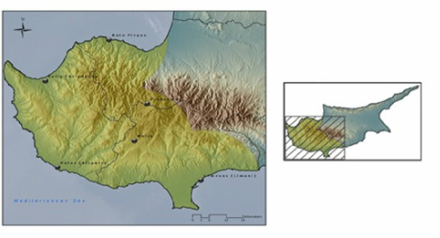
The meteorological measuring data network of Cyprus consists of 156 meteorological stations, recording rainfall and climatic data. For the measuring of the wind speed and direction, there are only 16 meteorological stations available. In this work hourly wind speed and direction data measured at 10 m AGL at six meteorological stations in the period 2001 – 2008, were utilized in order to calculate the speed statistics at the western part of the island. The stations (Fig. 1) are installed at Limassol’s Old Port (33o40΄, 33o03΄, 5m), at Polis Chrisochous (35o02΄, 32o26΄, 15m), at the airport of Pafos (34o43΄, 32o29΄, 8m), at Mallia (34o49΄, 32o47΄, 645m), at Prodromos (34o57΄, 32o57΄, 1380m), and at Kato Pirgos (35o11΄, 32o41΄, 5m) and they are all operated by Cyprus Meteorological Service.
The WAsP algorithm
WAsP is a widely used program for predicting wind climate, wind resources and power production from wind turbines and wind farms. The predictions are based on wind data measured at stations in the same region. The basis of the infrastructure of WAsP model is to provide a suitable database for estimating the wind flow. Its physical model is based to the modification of the flow in the atmospheric boundary layer taking into account the effects of the complex terrain, the sheltering effects due to buildings and other obstacles, the local roughness length of the areas at the studying region, and the modification of the wind imposed by the specific variations of the height of ground around the meteorological station. WAsP ensue a procedure in which the regional wind climatology of a station is used as input to be resolved and following the respective opposite procedure to find out the wind climatology around the site (Mortensen et al, 1993). The regional climatology, the station site’s description and the physical model is used in order to transform the measured data set of wind speed and direction from any station to what should have been measured at the station’s location if the surroundings were flat and homogenous terrain without any effects of obstacles nearby. In particular, the application uses the extrapolated statistical review data for stations as a regional climatology. Then, the corrected logarithmic profile model for the wind flow is used to take into account the topographic and terrain roughness effects, and thus, a boundary unified wind for the studying region is extrapolated as a representative Geostrophic Wind. After this, the application re – allocates the wind flow at each resource grid point along the area of interest, while at the same time emends due to local topographic and roughness effects. The program includes a complex terrain flow model, a roughness change model and a model for sheltering obstacles (Mortensen et al., 2004). WAsP requires a fraction of the computational cost compared to the advanced and more universal Computational Fluid Dynamics (CFD) models such as the Reynolds average Navier Stokes (RANS) model and have been proven to be as capable to reproduce the average neutral ABL velocity fields over gentle terrains. It makes use of input records that typically include roughness maps, wind measurements, and topography maps and contains sub-models for horizontal and vertical extrapolation of wind data taking into account sheltering obstacles, downloaded by surface roughness changes, and terrain height variations. In the specific application, the topography data used to create the wind resource maps were taken from two different sources. Firstly the digital elevation map (DEM) of Cyprus was converted to height contours with a 10m resolution. Furthermore, a linear roughness change map was created from the Corine Land Cover polygons of 2000, by using typical predefined values for the roughness length depending on the terrain surface characteristics. Specifically, the type of the land cover has been categorized and calculated depending on the weighted surface of the obstacles, related to the type of the vegetation, the adjacent settlements and the existence of water masses as sea or lakes. All the information was obtained by Corine Land Cover suffix. However, the modelling procedure demands the conversion of the polygonal Corine Land Cover suffix to linear suffix – cover through ArcGISTM. The purpose of this transformation is to provide with the neighbouring values, concerning the type of vegetation, from the linear data in each case (see Figure 2). Then, the values that represent the surface type are converted to their corresponding representative roughness length value as it is defined in the manual of WAsP (Mortensen et al, 2004). Summarizing, the outcome of WAsP is a Wind Atlas that can be subsequently used for the estimation of wind climate and wind power potential, as well as for siting wind turbines. Given the wind measurements at one site, WAsP calculates typical free upper atmospheric conditions by estimating the effect of the surface to the wind vector, due to the topography and to the surface roughness. Then, applying the inverse procedure, WAsP estimates the corrected wind regime to the surrounding area, assuming uniform atmospheric conditions (Akylas et al., 2001; 2003; 2005). It is evident that as the coverage by in situ measurements increases the predictions become more accurate, especially due to the assumption of common atmospheric conditions. Thus it is advisable to apply WAsP in a range around 10 Km around the measuring site. In our case, the course resolution of the measuring sites allowed for the application to circular sectors of 20Km radius, around each measuring site. Given the fact that the results are further aggregated using binomial law, the prediction errors are expected to decrease, especially when all the available stations will be used.
Basic References
Akdağ, S. A. and Dinler, A. (2009). A new method to estimate Weibull parameters for wind energy applications. Energy conversion and management,50(7), 1761-1766.
Akylas E, Tombrou M, Panourgias J, Lalas D. (1997). The use of common meteorological predictions in estimating short term wind energy production in complex terrain. In: Watson R, editor. Proceedings of European wind energy conference, Dublin Castle, Ireland, 1997. p. 329-32.
Akylas, E., Lalas, D. P., Pesmajoglou, S., Sakellariou, N., Tombrou, M. (1999). Investigation of the effects of wind speed forecasts and economic evaluation of the increased penetration of wind energy for the island of Crete. In EWEC’99, p. 1074-1077.
Akylas E., Tombrou M., Lalas D., Zilitinkevich S., Surface fluxes under shear-free convection, Q.J.R.Meteorol. Soc. 127, 2001, 1183–1197
Akylas E., Tsakos Y., Tombrou M., Lalas D., Considerations on minimum friction velocity, Q.J.R.Meteorol. Soc. 129, 2003, 1929–1943
Akylas E., Tombrou M., Reconsidering a generalized interpolation between the Kansas type formulae and free convection forms, Boundary-Layer Met. 15, 2005, 381–398
Beller, C. (2009). Urban wind energy-state of the art 2009. Danmarks Tekniske Universitet, Risø Nationallaboratoriet for Bæredygtig Energi.
Chompoo-inwai, C., Leelajindakrairerk, M., Banjongjit, P. F., and Wei-Jen, L. (2008). Design optimization of Wind Power planning for a country with low–medium–wind–speed profile. IEEETrans. Indus. Applic. 44:1341–1347.
Georgiou, A., H. Polatidis, and Dias Haralambopoulos. "Wind energy resource assessment and development: Decision analysis for site evaluation and application." Energy Sources, Part A: Recovery, Utilization, and Environmental Effects 34.19 (2012): 1759-1767.
Gungor, A., and Eskin, N. 2008. The characteristics that define wind as an energy source. Energy Sources, Part A: Recovery, Utilization and Environmental Effects 30:842–855.
Jacovides, C. P., Theophilou, C., Tymvios, F. S., & Pashiardes, S. (2002). Wind statistics for coastal stations in Cyprus. Theoretical and applied climatology, 72(3-4), 259-263.
Lee, A. H. I., Chen, H. H., and Kang, H. 2009. Multi-criteria decision making on strategy selection of wind farms. Renew. Energy 34:120–126.
Mortensen, G. N., Heathfield, N. D., Myllerup, L., Landberg L., and Rathmann, O. (2004). Getting Started with WAsP, Roskilde, Denmark: RisØ National Laboratory.
Pashardes, S., and Christofides, C. (1995). Statistical analysis of wind speed and direction in Cyprus. Solar Energy 55:405–414.
Seguro, J. V., & Lambert, T. W. (2000). Modern estimation of the parameters of the Weibull wind speed distribution for wind energy analysis. Journal of Wind Engineering and Industrial Aerodynamics, 85(1), 75-84.
